
Several months ago we took an in-depth look at MagicPlan with their updated LiDAR scanning capabilities and compared how effective it was against traditional pen & paper approach. We found that the LiDAR on it’s own was pretty “naff” when it comes to accuracy. Today we are looking at another option available using LiDAR to see if this might just be a software thing…
MagicPlan
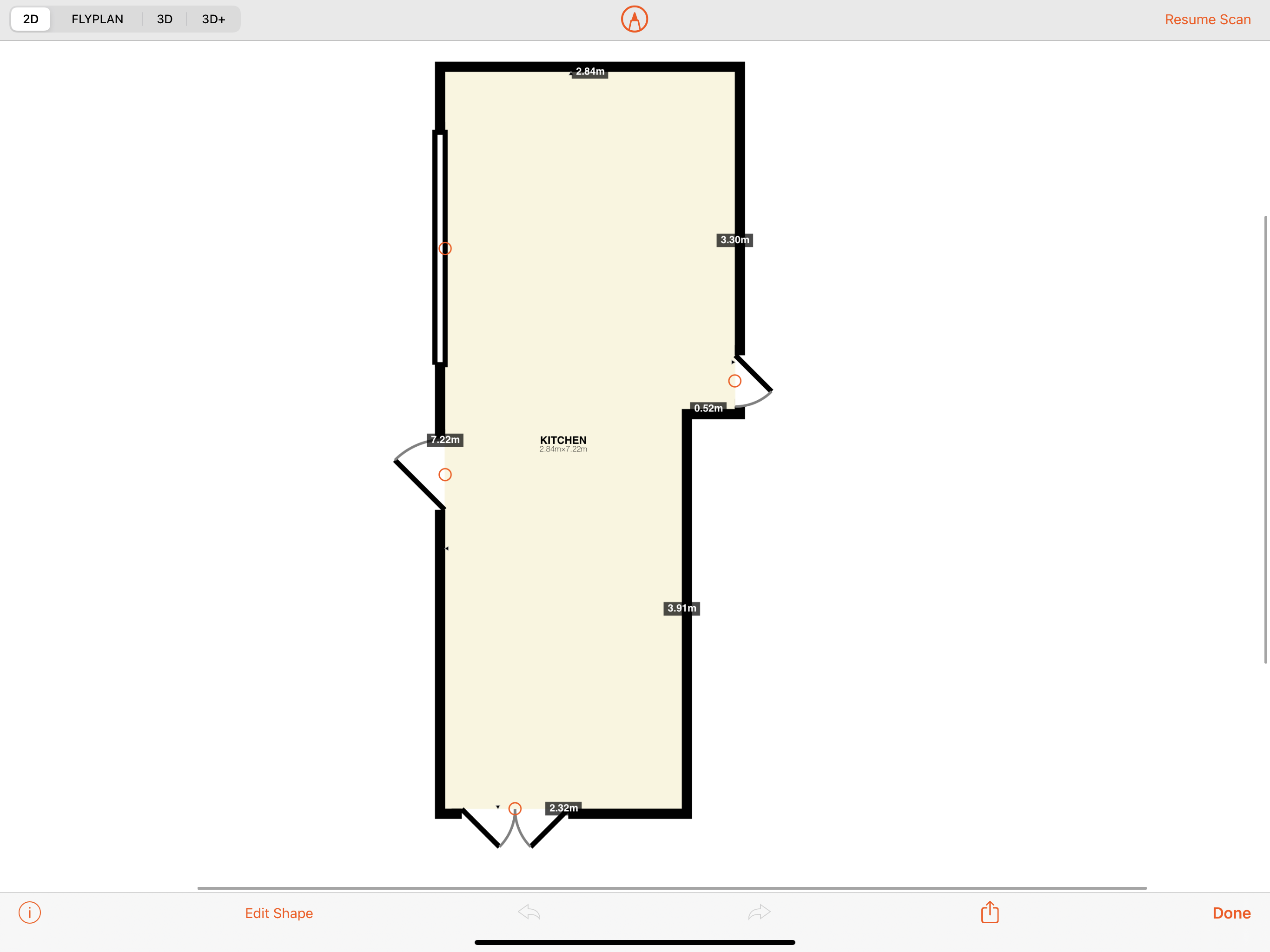
Let’s quickly recall our findings from our review of MagicPlan:
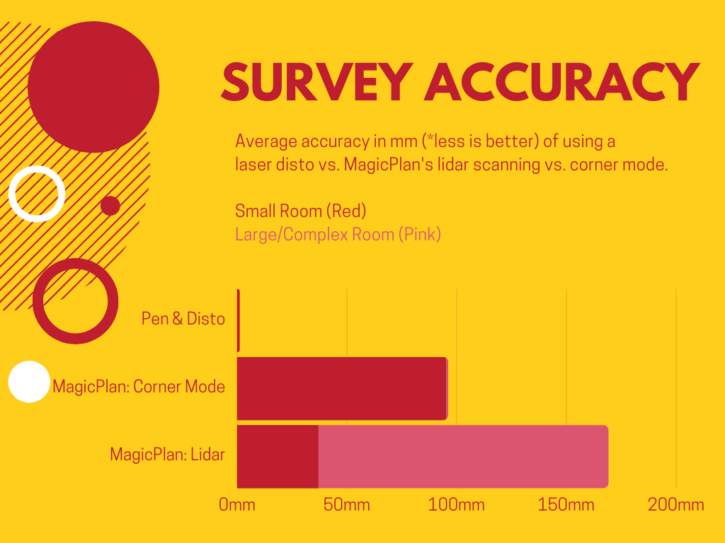
The 3 factors we addressed were accuracy (measured in mm), time taken to survey & BIM information. When we combined LiDAR-assisted MagicPlan with a bluetooth laser disto, our accuracy was spot-on and our times were speedy. We also had various options available to export BIM data – allowing further time savings post-survey. But, if only we could leave the laser disto at home all together! It just wasn’t accurate enough, with accuracy averaging within 150mm for the large test room.
RoomScan LiDAR
Carrying out a measured survey in RoomScan involves mapping the face of walls, similarly to MagicPlan, using LiDAR measurements and then selecting each wall as you navigate around a room. After comparing time taken to survey the same large room as per our previous testing, it does this in more or less the same time as MagicPlan when combining with disto measurements. Putting in disto measurements on RoomScan is a little slower than MagicPlan, however the initial room footprint set up by scanning the walls is very quick indeed, literally just seconds compared with several minutes on MagicPlan.

Furthermore, RoomScan picks up on small wall reveals/returns and hard to reach areas much more easily. Overall, unless you aren’t planning on using a disto, this makes no odds as door/window/opening placement is clunkier – there’s also no autodetection of these components as MagicPlan has – and so the overall amount of time spent in either app is the same.
MagicPlan exports CAD files, notes and pictures as does RoomScan. Here’s where the two apps differ: MagicPlan can export clean 3D models ready for Sketchup and other software. RoomScan on the otherhand, can create”point clouds“. You’re likely familiar with conventional 3D laser scanners that create point cloud information, typically with larger projects or conservative approaches to as-builts.
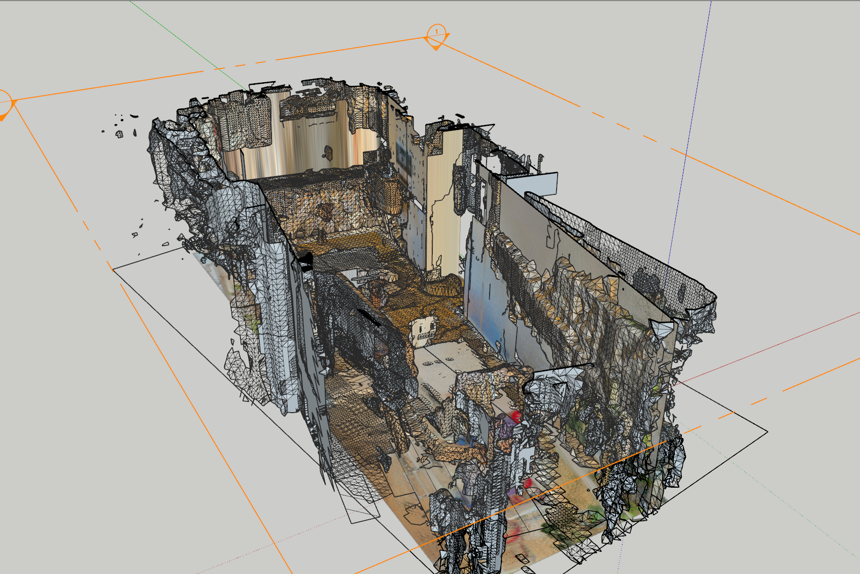
RoomScan can export point cloud into a few other formats, notably SketchUp friendly .DAE …. Although as you’ll see by swiping the image below, the conversion to DAE in Sketchup is not ideal!

The latest iteration of SketchUp has seen support for .PLY (point cloud) files with the Trimble Scan Essentials extension. At $550 p/a you might consider this on the steep side; and I’m not sure where the market lies for this software, as larger firms are likely using other software to handle their point cloud data. For individuals or small practices – if you haven’t already – you might want to familiarise yourself with the swiss-army knife that is Blender, the 3D modelling software, which you may be interested to know can import .PLY files straightforwardly and unlike SketchUp, should still run relatively smoothly under slight pressure on your system. [This frustrates me soo much about SketchUp if you can’t tell]
What’s the use case for the point cloud then? Accuracy is ok, so you could use it for measurements, but it’s not good enough for any critical dimensions. What I can see is this being useful for providing additional context to all your measurements and survey data, particularly in difficult areas to measure such as in loft spaces (attics) with cramped and dark conditions, LiDAR works perfectly well here; the only aspect in which you will have trouble getting data is with heavily glazed areas, as the pulsed lasers can’t get a reading. Another useful area you might look to count on LiDAR could be for site data where you need capture various structures and features, certain details of the elevations or topography, particularly on complex sites with sloped landscaping or varying levels of hardscaping which would otherwise be tricky to sketch out in 2D.
Now there’s one last trick to the RoomScan app which makes use of point cloud and it’s in AR! It’s not the prettiest and you have to use your imagination a little, however this can help take you one step further for immersion that you just can’t get from photos or videos. This relates nicely to the comment above regarding giving context. See below for a video on what this looks like. For the curious, the point cloud data was taken from a 5-10 minute scan of the room, it’s possible to get a better quality scan with more time or additional passes.
A note on pricing:
A big downside to this is app is the cost, at £9.99 per month. In comparison, MagicPlan is free for 2 projects and then also £9.99 per month, although you can export the data and delete projects to stay within your limit.
Overall, for the cost I’m sticking with MagicPlan. Having seen the advantages of point cloud data – particularly for obtaining data in hard to reach areas – i’ll be keeping a look out for more apps that fit this purpose.
That’s all for now, thanks for reading 🙏
You can find links below to try out the apps discussed:
RoomScan LiDAR for iOS

Hi, thanks for the review, much appreciated. When you exported to DAE it looks like you might have changed the 3D+ option in settings to “3D Model”. For a nice clean 3D export, try tapping the 3D view and exporting that.
AI recognition of floor plan items is coming in a few days and will have capabilities never previously seen.
Thanks again for considering RoomScan.
Hi Max, many thanks for your comments and congratulations on the app which we think is fantastic — we were very impressed by the LiDAR integration.
We have used the standard 3D mode with the scaled planes. It’s a nice way to visualise the floor plans, although we thought it would be great if this could include 3D assets of the walls, doors & windows. By the sounds of it perhaps you’re already working on something along these lines.
Regardless we’re very much looking forward to seeing what developments you have in store!
It would be interesting to know what you thought of these in comparison to the floorplan services offered by other LiDAR integrated AR apps like Canvas and Matterport. Cheers!
It would be interesting to know what you thought of these in comparison to the floorplan services offered by other LiDAR integrated AR apps like Canvas and Matterport. Cheers!
And thanks for the great comparison!
Hi, we’re currently using Canvas for surveys, we love the parallel detection feature it has which makes the spaces more linear. The only thing Canvas doesn’t do is give you a plan view of what you’ve captured, should you see that as a desirable feature. We’ve tried Matterport capture and found it quite clunky though this was using a mobile phone as opposed to their own Matterport cameras that they offer, hope this helps!